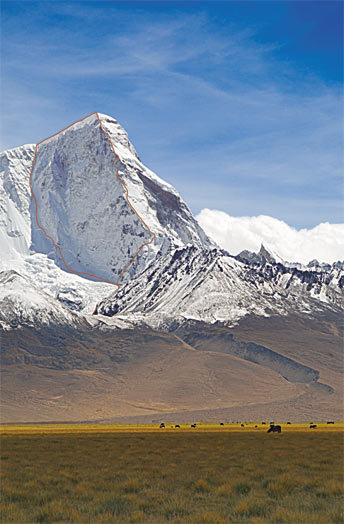
The north face of Chomolhari (7326m), Himalaya, Tibet, showing the two lines climbed by the 2006 Slovenian expedition: (left) Blagus-Cuder-Kladnik-Krmelj (TD+ 80 degrees, ca. 1900m) and (right) Prezelj-Lorencic (ED2: M6+ 70 degrees, ca. 1950m). Plagued by high winds and difficulties up to M6+ on the Northwest Pillar, Prezelj and Lorencic took six days on their ascent. Prezelj, who led the entire climb, freed all the difficulties and compared the route to the Golden Pillar of Spantik (7027m). [Photo] Marko Prezelj
Chomolhari, North Face, New Routes. Ten years ago, looking through a Chinese book about the Himalaya, I noticed a small picture of a pyramid-shaped mountain on the Tibet-Bhutan border and wrote down its name:+#8200; Chomolhari (7326m). When I tried to do more research, all I could find were some Internet pictures. I learned, however, that the heavy Chinese military presence in the area made travel there not so simple.
But in 2004 Roger Payne and Julie-Ann Clyma managed the fourth ascent of the peak, via the South Ridge (ca. AD). By the time I met Roger, I’d already asked for a climbing permit, and he was able to fill in some of the missing beta.
In September 2006 Boris Lorencic, Rok Blagus, Tine Cuder, Matej Kladnik, Samo Krmelj, Damijan Mesko (our doctor) and I set our base camp near the holy lake of Chomo Lharang (ca. 5100m) under the north face of Chomolhari. Fresh snow covered the mountain, while spindrift plumes streamed into the air off the northwest ridge.
To acclimatize, we climbed three summits (ca. 5700-5800m) on the side ridges above our camp. Meanwhile, the snow settled and appeared safe for higher acclimatization. We chose the ca. 6900-meter-high peak east of Chomolhari, which our kitchen assistant Tsering called Jangmo Gopsha. Over two days we climbed a snow-and-ice line between the north-face seracs to the east summit. The snow remained knee deep, with short segments up to sixty degrees. While we were gone, the wind knocked down our kitchen tent, mess tent, storage tent and two sleeping tents. Its strength earned it a place as a respected expedition member.
October 12: we made our first bivy at the base of the Chomolhari’s north face and began climbing on Friday the 13th. Rok, Tine, Samo and Matej picked the left couloir (TD+ 80 degrees, ca. 1900m) and followed it for two days to the summit.
Boris and I selected the northwest ridge. From the bivy we climbed a couloir of more knee-deep snow and some hard ice sections that traversed right onto a mixed buttress and up the ridge crest. The wind grew stronger, and we broke through thirty centimeters of snow as we climbed. We dug a bivy in a cornice under a roof.
The next day we took only spare gloves and some water (which froze); we hoped to push to the summit if the conditions weren’t too bad. The wind blew spindrift in our faces, making it difficult to see as we climbed vertical sugar snow and thin ice poorly adhered to the rock (up to M6). At the end of the second snow section, we found another refuge from the wind, then down climbed and rappelled to our original bivy. In the morning we packed our rucksacks and climbed back to the (iced-up) shelter.
Day 5: three long mixed pitches gave way to more deep snow and the last hundred meters to the windy summit. On the descent, our old footsteps appeared like twenty-centimeter-high snow mushrooms. We bivied in our first spot and reached base camp the subsequent day. Overall, logistics and tactics may have played a more important role in our route (ED2: M6+ 70 degrees, ca. 1950m) than did technical difficulty.
–Marko Prezelj, Kamnik, Slovenia