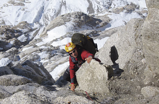
Louis-Philippe “LP” Menard on the first ascent (in warm conditions) of the Canadian Direct (Alaska Grade 6: M6 5.9, 8,000′) on May 29. Menard and Maxime Turgeon completed the route in fifty-eight hours from the bergschrund to 20,200 feet, where high winds and zero visibility forced them to descend.
[Photo] Maxime Turgeon
On May 7, after a day of Roadhouse breakfasts and West Rib burgers in Talkeetna, Will Mayo, my partner for the first two weeks of this trip, and I lugged our gear to the Kahiltna base camp. There, we spent a couple of days feeling depressed about the now-departed Moonflower and acclimatizing on Mt. Crosson (12,800′) before we went to have a look at our main project: a new line on the south face of Mt. Foraker (17,400′).
Early on May 12, paying as little attention as we could to the hanging serac in the center of the face, we worked our way up the 1,000-foot initial snow ramp. A mixed pitch led us to 600 feet of pure, blue, ninety-five-degree alpine ice. We climbed this feature for two pitches before deteriorating ice conditions forced us to the left, into mixed ground alarmingly close to the serac. Soon enough, however, after fourteen hours on the go and 2,500 feet up the face, we were out of harm’s way.
Another 1,000 feet and our only bivy option was to chop a half ledge through the ice slope. The cold forced us out of our two-person bivy bag in the middle of the night, and we picked up our tools again, only to stop at 1 p.m. under a boiling sun at 12,500 feet. The same day, we gained the French Ridge at 13,000 feet, which we followed 500 feet higher. A gray band was forming on the horizon from the southwest. First hesitant, I finally agreed with Will to bail. Ten hours and all our cord and webbing later, and only twenty minutes after we left the basin, the serac in the middle of the face collapsed, erasing both our line of ascent (WI5+ M6 A0, 5,500′) and descent.
Louis-Philippe “LP” Menard, my partner for the rest of the trip, joined us on May 19. LP and I spent seven days acclimatizing on the West Buttress, then skied back down to base camp. On May 27 we skied into the East Fork of the Kahiltna and set up our camp at the bottom of the icefall below Denali’s imposing south face. Around 7 p.m. the low clouds cleared from the valley, so we grabbed our skis and went to scope our prospective route: up the middle of the huge pillar at the start of the wall, left toward the Japanese Direct, then right toward the American Direct–a “real direct!”
We left camp at 7 a.m. on May 28 in warm temps and climbed 3,000 feet (up to 5.8) on beautiful granite interspersed with occasional ice and frequent rockfall. At 2 p.m. the next day, after a brew stop in the sun, we joined the upper buttress of the American Direct, which we followed for the last 3,000 feet. We reached the enormous gendarme at 17,500 feet around 10 p.m. in increasing bad weather and low visibility, snoozed a bit and started back up the remaining 1,800 feet at 9 a.m., simulclimbing the long ice and snow ramps. At 7 p.m., in snow and whiteout conditions, we manteled over the ridge and followed it to 20,200 feet, where high winds and zero visibility forced us to contour around the true top and start the descent down the West Buttress. A near fall over an unseen drop convinced us to bivy again at 19,200 feet. We managed to rest for three hours, until with hypothermia setting in and our stove working poorly, we gave up and zigzagged down through the Football Field in poor conditions. We finally found Denali Pass and reached high camp, where friends welcomed us with hot drinks. Later the same day, we continued down to the 14,000-foot camp and the following day down to base camp.
We counted about thirty-eight pitches, most of which were 100- to 150-meter simulclimbing ones. While the rock quality throughout was quite good and variations multiple, we took the line that seemed the most logical and direct. The 8,000-foot Canadian Direct (Alaska Grade 6: M6 5.9) is indeed “the real direct!”
–Maxime Turgeon, Montreal, Canada