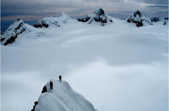
The summit of Mt. Worsley (1104m), South Georgia, which the French team climbed on December 2 for its first ascent. Philippe Batoux, Manu Cauchy and Lionel Daudet made the third recorded traverse of the island’s ca. 106 miles between November 26 and December 15. [Photo] Courtesy of EXPEDITION GEORGIA SAT 2007
The French mountaineering team comprised of Philippe Batoux, Manu Cauchy (aka Doc Vertical) and Lionel Daudet, and Isabelle Autissier–a sailor based on the specially modified sloop, the Ada 2, out of Ushuaia, Argentina–and her two mates, Agnes Lapeyre and Tristan Guyon, succeeded in their two-and-a-half month sea-supported ski mountaineering expedition to South Georgia by making a crossing of the remote island and climbing four peaks, two of them via new routes. (The November 28, 2007 NewsWire documents their early progress.)
On November 8 they arrived in Grytviken, a settlement populated solely by seasonal museum employees, and subsequently completed the first ascent of Sheridan Peak (ca. 900m), the sixth ascent of the island’s tallest point, Mt. Paget (2934m), the third ascent of Surprise Peak (ca. 955m) and the first ascent of Mt. Worsley (1104m).
The second half of the journey proved more difficult because poor weather, unexpected obstacles, rough seas and defensive colonies of sea lions made the climbing and rescue logistics unpredictable.
In early December a break between storms appeared, and the team attempted two peaks near the Sea Leopard Fjord. The three mountaineers summited Mt. Worsley on December 2, but 30 mph winds and zero-visibility conditions prevented them from climbing Trident the next day. Daudet reported that Worsley was “breathtaking, but not very hard.”
Batoux, Cauchy and Daudet made good progress traversing the island and returning to the boat to resupply and rest over the next week. They encountered severe weather, so they were not dropped at Helland Glacier, for the last leg of their crossing, by the Ada 2 until December 12. The boat had a rough time navigating the walls of ice that shift constantly around the island and the brash, a layer of ice that covers the water’s surface.
“Travel via the southwest meant that the slightest mistake, the slightest accident, however small it might be, with the least gust of wind from the south, would have been a trap, without relief and with no means of escape,” Cauchy reported.

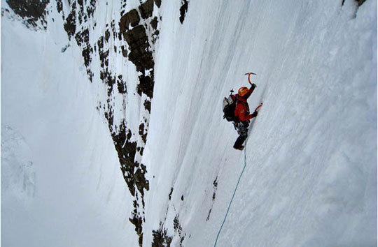
Tackling steep terrain on Sugartop, the team’s final objective. Poor weather turned them back just shy of the summit. [Photo] Courtesy of EXPEDITION GEORGIA SAT 2007
Daudet and Batoux found a route between the perilous ice floes, and the mountaineers dropped off their pulkas and supplies. They continued from the Helland Glacier to their final destination, Larsen Harbour, where they rejoined Autissier and the Ada 2 on December 15.
Crossing the Helland Glacier was routine the team reported. However, route finding on the crevassed Brogger Glacier was a challenge despite their GPS devices as the team’s map showed little detail (1cm:200,000km).
“We expected to plan our routes,” Cauchy said, “but it was impossible because some sections remained invisible [from below]. Every pass and every glacier that seemed so insignificant on the map was capable of blocking passage through a complex labyrinth of cracks or snow slopes impassable with a pulka.”
Despite the harsh weather, the team took only three weeks, from November 26 to December 15 to cross the island’s ca. 106 miles–not to mention eleven day-long excursions on skis in that same period. Before embarking on the 2000-kilometer crossing to Tierra del Fuego, the team attempted one more peak, Sugartop (2223m). They encountered 50 mph winds and rotten rock; the nearby summit caught in the clouds, the team decided to turn back.
The Ada 2 left South Georgia on December 31, and after almost two weeks of passage the ship returned to its homeport of Ushuaia, Argentina, and the expedition concluded on January 13.
South Georgia is the largest of a group of islands in the southern Atlantic Ocean known as the South Georgia group. The islands are part of a larger British Overseas Territory ca. 864 miles east-southeast of the Falkland Islands. British Antarctic explorer Ernest Shackleton led the first east-west crossing of South Georgia during a Trans-Antarctic expedition from 1914 to 1917. The island has been crossed twice northwest to southeast: once by Duncan Carse, who was making a map of South Georgia. It took him five years from 1951 to 1956. The second was by the English team of Patt Lurcock and Angus Finney in 1999, and it took them a month to cross the island by the less-exposed north coast.

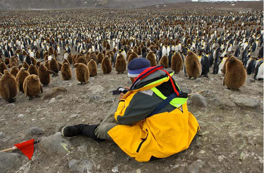
A sea of penguins in St. Andrews Bay. [Photo] Courtesy of EXPEDITION GEORGIA SAT 2007