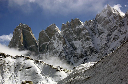
The Neverseen Group, as seen from the Grmovseks’ advanced base camp. The pair encountered snow plastered on the walls of even steep and south-facing peaks. [Photo] Andrej Grmovsek
In September 2007, my wife Tanja and I traveled to Miyar Nala, Himachal Pradesh, Indian Himalaya. We decided on this destination because there are no climbing permits or bureaucracy problems that are so typical for the rest of the Indian Himalaya. The area is getting more and more explored, but there are still some very interesting walls with no or only a few climbing routes to-date.
We traveled as simply as possible and arrived in Tingrit, a small village at the end of the road in Miyar Nala (Valley) on September 8. After a two-day foot approach with two horses for our stuff, we came to base camp under Castle Peak in a mix of rain and snow. The next three weeks had plenty of unstable and bad weather, but also two nice spells.
On September 16, we climbed the east ridge of a rounded mountain we called Toro Peak (ca. 4850m) for acclimatization. We called our route Toro Ridge (V+, 300m) The peak has been climbed previously and has a hiking ascent option. We returned to base camp but decided to go for another acclimatization climb after a day of rest.
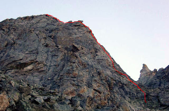
Toro Ridge (V+, 300m, 450m of climbing) on a rounded mountain the Grmovseks called Toro Peak (ca. 4850m). [Photo] Andrej Grmovsek
We made an afternoon approach to the base of the mountain and took a short bivouac under a boulder. In the night, we climbed 500 meters of a loose gully, and with the first sun beams, we started climbing perhaps the most aesthetic peak in the area. A perfect right-angled ridge led to the summit, with a huge window of rock at the top. After ca. 500 meters of climbing, we were surprised by old slings, as we thought we were climbing an untouched line. A bit angry, we continued climbing. The last pitch to the arch, which formed the top of the peak, was seriously rotten and loose and was the crux of this route. By early afternoon we were celebrating on a perfect summit. We were even happier when we didn’t find any rappel slings at the top.
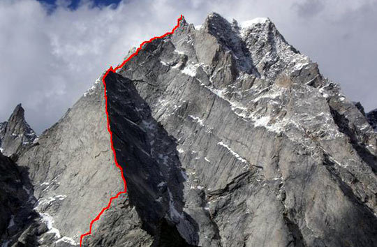
Korklum Gou-Window Peak (ca. 5600m) and the route Shangrila Ridge (VII R, 600m, 900m of climbing) [Photo] Andrej Grmovsek
After returning home, we read a new AAJ report about an unfinished Canadian try on more or less the same line. This provided confirmation that we were the first people on this summit. So we named the peak Korklum Gou-Window Peak (ca. 5600m) and the route Shangrila Ridge (VII R, 600m). After that climb we spent five rainy and snowy days in base camp with Slovak climbers Andy and Juraj. The temperatures fell significantly and a lot of fresh snow accumulated on the upper walls. After the weather improved we decided to move to the Tawa Glacier side valley, under Neverseen Tower. The approach to this advanced base camp is almost 1000 meters in altitude gain, and half of it wanders on an unstable glacial moraine. Fresh snow on moving and slippery moraine stones made walking very hard and dangerous. Even south-facing, steep walls like Neverseen were plastered in snow. So we decided to stop on the glacier and wait until the walls were clear of snow.
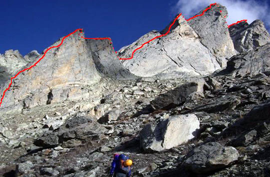
Trident Ridge (VII/VII+, 500m, 1000m of climbing) on Premsingh Peak (ca. 5200m). The Grmovseks experienced “enormous cold for rock climbing, even in the sun.” [Photo] Andrej Grmovsek
So as not to lose time in such nice weather, we climbed a nice three-tower east ridge opposite our temporary camp. But it was snowing again all night, and we waited one more day so our secondary climb could dry. Then, on September 29, we finally climbed Trident Ridge (VII/VII+, 500m) on a virgin peak we called Premsingh Peak (ca. 5200m). It was enormously cold–for rock climbing–even in the sun, and it became clear to us that our wish of climbing Neverseen was not a suitable option. With only few days left, we returned to base camp, and on October 1, we climbed our last route on the rock tower David’s 62 Nose (ca. 4950m) on Castle Peak’s south face. We called our route Lufoo Lam-Windy Way (VII+, 350m). This tower had been climbed previously by Italians.
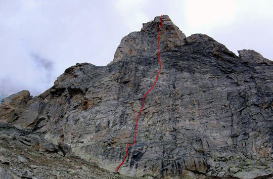
Lufoo Lam-Windy Way (VII+, 350m, 400m of climbing) is on a rock tower called David’s 62 Nose (ca. 4950m) on the south face of Castle Peak. [Photo] Andrej Grmovsek
Climbing in this remote and un-crowded valley was a great adventure. It is nice to move around without any control–no officers–and to deal only with very hospitable local Buddhist people. The climbing itself was enjoyable because of the featured rock, which is something between granite and gneiss and is far more solid than it looks. We used only removable protection and left only a few rappel slings on the mountains to keep the area as adventurous as possible. We really enjoyed climbing our four new routes, on two virgin peaks, but our wish of climbing something new on Neverseen remains. I suggest the late summer season is probably not the best time for rock climbing in this area because of low temperatures. There is still something worth climbing and a lot worth exploring in this region.
For remote regions like Miyar Valley, it is very important to have accurate information of previous expeditions, their attempts and routes. We discovered that some altitudes of peaks were not measured or reported correctly in the past. Before our expedition we tried to get as much information as possible, but still we figured out that some peaks had seen attempts and we couldn’t get any information on them. Climbers from Italy and Slovakia put together a sketch map with names of peaks, information, pictures and altitudes, but that information is not updated any more. It would be great to continue that kind of work for any remote region.
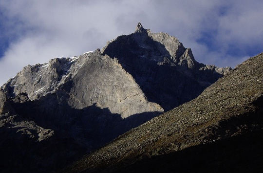
Korklum Gou-Window Peak (ca. 5600m). The route Shangrila Ridge (VII R, 600m, 900m of climbing), climbs the obvious ridge line across the center of the photo, then curves back to the right and finishes on the prominent summit tower. [Photo] Andrej Grmovsek