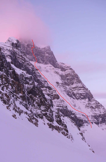
Editor’s Note: From March 26-28, 2008, Vince Anderson and Steve House committed to new ground on the serious, rarely climbed north face of Mt. Alberta (3619m). Although not technically climbed during the calendar winter, their new route (WI5+ M8 R/X, 1000m) marks the first time Alberta’s north face has been climbed in full-on winter conditions (Steve Swenson and Kit Lewis’s September 1981 ascent–the second of the face–was made in late summer amid snowy conditions). What follows is Anderson’s report.

The north face of Mt. Alberta (3619m), Canadian Rockies, showing the new Anderson-House line (WI5+ M8 R/X, 1000m), which first follows mixed terrain right of the Lowe-Glidden, then crosses that route to access an ice pillar. The north face proper, now with only three routes, is rarely climbed due to the commitment involved and has only received a handful of ascents in the past fifteen years. Alberta’s north face remains to be climbed during calendar winter, but House and Anderson certainly encountered wintry conditions (including -20 degrees F temperatures) on their March 26-28, 2008 ascent. [Photo] Vince Anderson
After a recommendation from Barry Blanchard, Steve House and I began our attempt on the north face of Mt. Alberta in the Canadian Rockies on March 24, 2008. That first day began and ended at Steve’s truck and camper on the roadside–our goal was to ski over the Wooley Shoulder from the Icefields Parkway to the Lloyd McKay Hut, but after a frustrating and strenuous 4.5 hours of trail breaking on skis through deep facets under an unsupportive crust, we decided to make a cache near the moraines in the lower basin, around 2100 meters. We skied back out to the highway and spent the night in Steve’s camper truck there. Around 7:30 the following morning, we skied up to our cache, continued up and over the Wooley Shoulder with the gear and reached the Lloyd McKay hut around 2 p.m. After some recon of Alberta’s north face, which neither of us were familiar with, we found the rappel station leading down to the glacier below the north face and cached our rock hardware. We spent the night at the hut making water for the next day, packing and eating.
We left the hut at 4:30 a.m. on the 26th to find a bitter morning so cold it was hard to fully appreciate the beauty of an aurora on the northern horizon. We rappelled onto the north side with our rock gear as the sun broke–then I noticed I’d lost an ice ax during the rappel. I searched in vain for 30 minutes. Cursing and angry I made one final sweep at the base and came up with it from a small moat near a rock outcrop. We carried on toward the north face, reaching its base around 9:15 a.m. to find mostly clear skies and light winds: great crisp weather.
We climbed three easy but scrappy mixed pitches, up to M5, in the center of the first rock band–all other ascents have used two rock pitches farther right–to reach the base of the icy snowfield. We put the ropes away and soloed the incredibly steep (for snow climbing) face, passing the occasional bare ice patch. Near the Yellow Band, the snow yielded to the typical steely, hard, gray ice you’d expect on the north face. Though more taxing, this ground felt more secure, as we got good purchase with axes and crampons.
Just before noon we took out the ropes for two mixed pitches on low-angle crumbly rock through the Yellow Band to the base of the steep headwall. In addition to cold, deep snow, the weather had deteriorated. We considered bailing by traversing the Yellow Band to its intersection with the northeast ridge. Instead we decided to continue, as retreat would still be feasible (we convinced ourselves), from a short ways up the face.
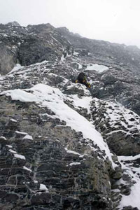
We could see the start of the Lowe-Glidden (L-G) route nearby but found a crack system about 60 meters to the right that appeared to have better winter climbing conditions. Two long, difficult pitches (M7 and M8 R/X) of high-quality drytooling led up and left to intersect the L-G route above its third pitch in a snowy alcove.
Here, the L-G moves up and right onto a buttress, but we found a steep and narrow ice pillar directly above the alcove (we had scoped this feature from the ridge crest the previous day). It was now just about dark, probably 9 p.m., and the ice above was the obvious choice. We climbed two pitches (WI5+ M7). After the exhausting bout (the cold, black ice was brittle and very hard to penetrate) we stopped atop a large snow mushroom and under another. We anchored here, mostly sheltered from frequent spindrift avalanches. Around 1 a.m. we were settled in for the cold night. Our down sleeping bags were slightly wet, but we hoped not to spend another night on the mountain; that hope would not come to fruition.
After 6 a.m. we woke and slowly worked out of our wet cocoons. Steve prussiked up 30 feet of rope we had fixed the night before. He had done the bulk of the hard leading the previous day, so it was my turn to take the sharp end. The next pitch went up a small ice corner to the end of the feature from which the water ice had emanated (the small cave at the top, we later found, would have offered a much better bivy spot). A small ledge system traversed right, toward the L-G and the summit ice slopes. The airy traverse across this ledge was covered in deep snow and required belly crawling (difficult with packs) and then precarious tip-toeing to reach a niche with more moderate ground above. Another few pitches of good mixed climbing up flakes, corners, and slabs covered in thin neve (M6/7) got us out of the difficulties and again intersected for a moment with the L-G exit pitch (we found a fixed angle piton here).

House leading the second pitch of the headwall; this pitch and the one just prior comprised the most serious mixed terrain. [Photo] Vince Anderson
Instead of moving right with the L-G, we climbed slabby mixed terrain above because we thought the exit onto the ice looked convoluted. The ground we climbed was probably less attractive in summer conditions but more reasonable under the cover of snow. A long, 150-meter pitch put us onto the summit ridge and gave us our first glimpse of the sun in two days. A pitch later we stopped on top, briefly, at 5:45 p.m. We followed the south ridge to try and descend the Japanese Route, but the long corniced ridge required cautious climbing and strenuous work breaking trail. On top of that, we guessed (incorrectly) about where to begin our descent onto the east face.
The descent gully we chose eventually intersected a large ledge system and snowfield. There we had to make a decision: continue into the unknown darkness or bivy again with little food and wet, useless sleeping bags. We decided to stay put and shiver through it. It was miserable.
Shortly after daybreak, we got out of our flat, frozen bags and packed up to continue down the wrong gully system. However, the morning of the 28th was a much finer day, and we were treated with brilliant warm sunshine on the east face. By 10 a.m. we were in the safety of the flat basin and gratefully took off harnesses, helmets and crampons in the warmth before slogging up the hill and skiing down to the road.