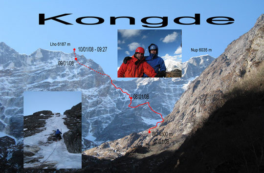
The line of the new Russian winter route Chicory (M4 WI4 5.7 80 degrees, 1200m but an estimated climbing distance of 2110m, Belousov-Novikov, 2008) on the north or Hungo face of Kwangde Lho (6187m). The picture top right shows Belousov (left) and Novikov on the summit; bottom left is Novikov leading the WI4 pitch. [Photo] Vladimir Belousov
Vladimir Belousov and regular climbing partner Alexander Novikov have recently made a calendar-winter ascent of Kwangde Lho (6187m) by a new route on the celebrated north or Hungo face. The Kwangde group lies in Nepal’s Khumbu region, and the pair’s original aim was a new route between the legendary Breashears-Lowe (ED2: WI6, 1200m, Breashears-Lowe, December 1982) and the Spanish route, Mandala (1150m, Lorenzo-Munoz, 1985: little information on the difficulties of this route). However, when they arrived below the face and scanned the wall with binoculars, they found conditions very dry, as often is the case in winter. There was no ice at all on this section of the face below the main summit, nor further to the left on the line of Extra Blue Sky (ED2, 1200m, Beaugey-Profit-Rhem-Ruby, 1996, only Profit and Rhem to summit). One possible line they saw might go without aid was the wall beneath the Kwangde Lho-Kwangde Nup col.
From time to time comment is made on the “heavy-weight” tactics of some Russian expeditions to major objectives; although Kwangde is small in comparison, the pair opted for a very lightweight approach, considering the time of year and the fact that they chose to make a full traverse of the mountain.
Belousov and Novikov started the climb on January 8, carrying two small rucksacks, one sleeping bag for both climbers and a Bibler tent. They took one 8mm rope, a small rack of Camalots, six ice screws and set of Jumars. Starting from a base camp at 4500m, they slanted left across the lower section of Kwangde Nup’s north face, climbing a couloir and rock band to reach the northwest spur descending from the summit of Lho. Below the central rock barrier and at much the same point that Mandala comes in from the left (and, it is believed, climbs close to the crest above) they made a horizontal traverse right. The crest above had looked difficult, probably succumbing to hard rock climbing with some aid; to the right lay icy mixed walls that could be climbed free. The two Russians eventually reached the southwest ridge about a hundred vertical meters below the top and made their second bivouac just below the summit. It was -20 degrees C, very windy, and they were unable to pitch the tent. They sat all night rubbing arms and legs to keep away frostbite and the next morning, January 10, reached the summit in clear weather at around 9:30 a.m. The climbing had been mostly 40-50 degree snow and ice, but there had been five difficult pitches. Three of these (M4; WI4; M3) were through the rock band above the narrow couloir on the first day; the fourth was the exit pitch onto the southwest ridge (M3 and 5.7), while the last was on the south side of the mountain just below the second bivouac (M2/M3 and WI3). On the first four the leader led without a sac, the second jumaring while carrying both.
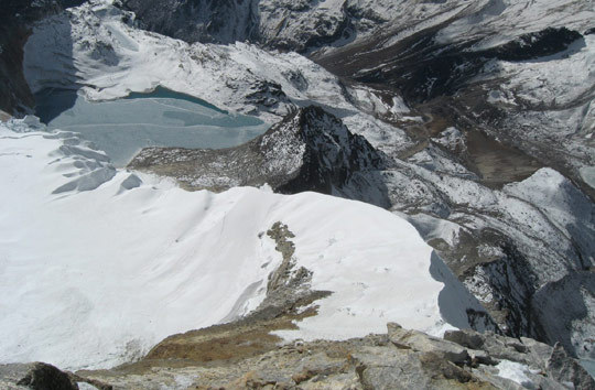
From the summit the pair descended the original route, making several rappels to reach the south ridge (Ishikawa-Iwahashi-Ogawa-Sherpas, 1978), which was hard ice. They descended this carefully, and the rocky ground beyond, to the frozen lake in the Lumding Valley. They walked straight across the middle of this and then down the snow-free valley until they could make the long and arduous climb back north to the Lumding La. Crossing this is notoriously difficult as tracks are vague, but the pair found the flag marking the pass and descended the far side for ca. 600 meters to a spur between two steep valleys. The path down the spur initially was marked but quickly became indistinct, involving sections of steep traversing on grass. About half way down the light faded, and they had to finish it the following day, reaching Pkhanding alongside the Dudh Kosi on the 12th.
Although it is hard to say whether this route has any common ground with Mandala, Chicory (M4 WI4 5.7 80 degrees, 1200m but an estimated climbing distance of 2110m, Belousov-Novikov, 2008) is probably the easiest way to reach the summit ridge on the Hungo face. But for the two Russians it was their first new route in the Greater Ranges.

A bird’s eye view of the frozen lake in the Lumding valley south of Kwangde. Looking from the summit of Kwangde Lho down the south ridge, the route of the first official ascent of the mountain by a Japanese-Nepalese team in November of 1978. [Photo] Vladimir Belousov